Water: A Life Force Harnessed as News
Water is the essence of life, and its cleanliness, availability, and our use and abuse of it are stories meriting reporters’ and editors’ attention. Yet as Stuart Leavenworth, who covered water issues for The Sacramento Bee and describes the wide array of issues he took on, reports: “To my chagrin, I had the beat largely to myself for four years. Across the country, papers have tackled problems of water pollution and degradation, but have overlooked fundamental issues of supply—and sustainability. This is curious.”
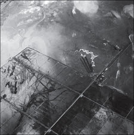
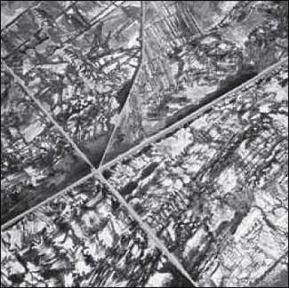
Areas on the lakebed that generate dust must be controlled with one of three approved dust-control measures: flooding with shallow sheets of water, establishing native salt-tolerant vegetation, or covering the surface with gravel. The lower portion of this photo shows the construction of an extensive underground drainage system that will carry away salty water and allow the soil to be reclaimed to the point that it will support native salt grass. Within two years this area will be a green meadow. The areas in the upper portion of the photo will have dust controls installed by the end of 2006. Photo by David Maisel/Caption by Ted Schade.
Owens Lake was a perennial lake at the terminus of the Owens River throughout historic time; the lake held water continuously for at least the last 800,000 years. Owens Lake is now an extreme example of the destabilizing effect on land surfaces caused by the extraction of surface water in desert regions.
Beginning in 1913, the Owens River was diverted in order to bring water to the city of Los Angeles, and by the mid- 1920’s Owens Lake was dry. For decades, the dry bed of Owens Lake produced enormous amounts of windblown dust. Indeed, the lakebed became the single largest source of particulate matter pollution in the United States, by one estimate emitting some 900,000 metric tons annually. The dust from the lakebed contains carcinogens such as nickel, cadmium and arsenic, as well as sodium, chlorine, iron, calcium, potassium, sulfur, aluminum, and magnesium.
The extraordinarily high air pollution levels recorded around the dry lakebed during dust storms have reached 25 times the levels of national clean air standards. The dust travels both north and south on turbulent winds channeled through the Owens Valley by the Sierra Nevada Mountains to the west and the White-Inyo range to the east; the toxic dust has been tracked by satellite some 250 kilometers to the south into the Los Angeles area.
The city of Los Angeles owns thousands of acres of Owens Valley lands, along with the rights to the water in the Owens River. The Owens River still flows through the upper part of the Owens Valley, but is then diverted into the Los Angeles Aqueduct 51 miles upstream from the point where it used to enter Owens Lake. Under California law, the Great Basin Unified Air Pollution Control District has been given the authority to order the city of Los Angeles to undertake reasonable measures to mitigate the air quality impacts of its water-gathering activities. After decades of legal wrangling, in 1998 Los Angeles was ordered to implement dust control measures to abate the toxic dust storms that come off the barren lakebed. These controls include the shallow flooding of thousands of acres along the eastern edge of the lake with a small percentage of the water that is diverted, as well as reclaiming some of the saline lakebed soils and establishing fields of salt-tolerant grass irrigated with hi-tech buried drip systems. Los Angeles continues to implement these dust controls and will complete the $400 million project by the end of 2006.
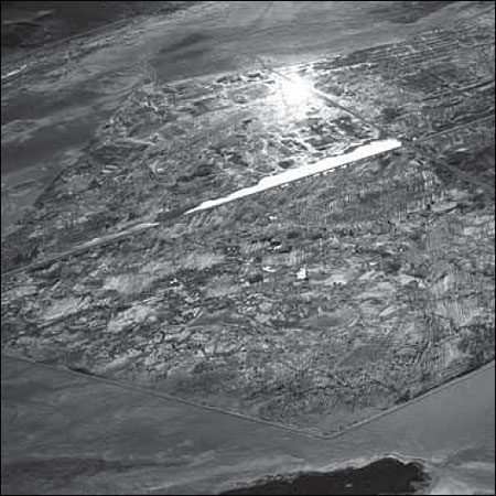
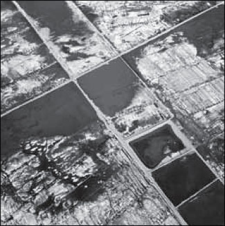
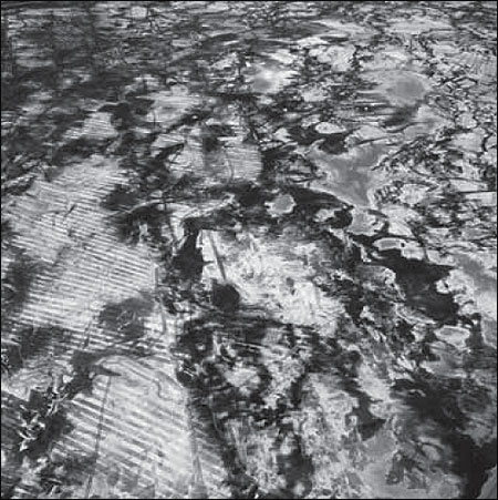
One of the methods used to control dust emissions from the dry portions of the Owens lakebed is known as shallow flooding. Los Angeles has constructed a large network of buried pipeline that takes a small percentage of water out of the Los Angeles Aqueduct and returns it to the lakebed for dust control. By the end of 2006, about 15,000 acres of dusty lakebed will be controlled with shallow flooding. The photographs on these pages show a portion of this shallow fl ooding. Water slowly fl ows from thousands of outlets across the playa and is captured by berms, then recirculated to the top. Not all of the lakebed needs to have standing water; the areas between the pools of water are wet enough to not emit dust. The visible hatched patterns are scars from attempts to level the surface with bulldozers. These scars will disappear in a few years as the water moves across these flattened areas. Photos by David Maisel/Caption by Ted Schade.

David Maisel has made aerial photographs of environmentally impacted terrain in the United States for more than 20 years in an ongoing project called “Black Maps.” The Owens Lake photographs are included in this project. See www.davidmaisel.com or www.lakeproject.org for more information and images.
This text is adapted from a story David Maisel wrote for Grist magazine.