Coverage of Terrorism
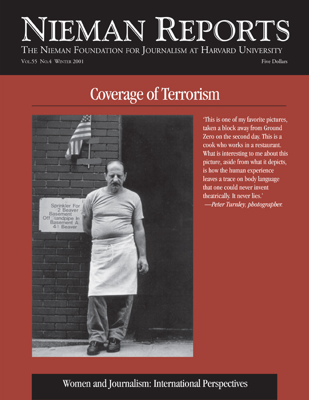
Through the night of September 11, 2001, photographer Peter Turnley took refuge in a second-floor office in a clothing store, its windows blown out by the force of the attack on the World Trade Center. As he tried to absorb what he was seeing, he documented the devastation. At dawn, he moved close to the site and fastened his journalistic eye on faces whose expressions evoke our feelings of loss. From covering war, Turnley knew that “the most important pictures…are after the battle, when one sees the human impact.”
www.spaceimaging.com
Space Imaging’s Ikonos one-meter resolution satellite is the premier source for civilian highresolution imagery, but at this writing its data collected over Afghanistan and environs has been effectively blockaded by the U.S. RELATED ARTICLE
“Press Access to Satellite Images is a Casualty in This War”
- Christopher SimpsonDepartment of Defense. Space Imaging Middle East in Dubai, UAE (www.spaceimagingme.com), Space Imaging Eurasia in Ankara, Turkey (www.sieurasia.com) and Space Imaging Europe in Athens, Greece (www.si-eu.com), are each franchises, in effect, of the U.S. company. Each also has its own downlink capability to gather imagery from Afghanistan and environs collected by Ikonos, U.S. Landsat satellites, and India’s mid-resolution IRS-C and IRS-1D satellites.
www.spot.com
Spot Image features considerably more satellites presently in orbit and a stronger image archive than its competitors, but most data are at about 10- to 15-meter resolution. This resolution is appropriate for most commercial applications and in some instances can be adapted to meet the needs of the news media. Spot Image’s new generation of higher resolution satellites is scheduled to be online during the spring or summer of 2002.
www.imagesatintl.com
ImageSat International, formerly known as West Indian Space Inc., features a 1.5- to three-meter resolution Eros A1 satellite that has captured images of the Afghan war that are unavailable elsewhere. However, ImageSat also boasts that it has won Department of Defense contracts similar to those that tied up Space Imaging’s satellite data during the conflict.
www.earthsat.com/environ/region
Earth Sat are image processing and analysis specialists. They provide infrared satellite imaging, GIS and agricultural and socioeconomic data on Pakistan and Southwest Asia, usually under contract to the United Nations, national governments, U.S. government agencies, the World Bank, or corporations.
www.digitalglobe.com
DigitalGlobe, formerly known as EarthWatch, successfully launched its QuickBird highresolution satellite in autumn 2001. It plans to offer full image-gathering capability during the first quarter 2002. DigitalGlobe, like several of its competitors, also markets imagery from Canada’s RADARSAT International, Russia’s space program, India’s satellite program, and other sources. Availability and currency of these data vary by region.
www.dfd.dlr.de
DFD-DLR, Germany’s state remote sensing organization, installed an advanced, mobile four-meter ground receiving station near Kitab, Uzbekistan, some months prior to the outbreak of war.
www.globalsecurity.org
GlobalSecurity.org is a space and international security-oriented think tank, most of whose analysts were formerly associated with the well known Federation of American Scientists satellite imagery Web site. The latter site has been significantly cut back, while GlobalSecurity.org’s site includes key materials gathered during the FAS project and a considerable amount of new data. The site is particularly useful for satellite imagery and high quality maps of the Afghan war zone, as well as an archive of publicly released DOD imagery.
www.orbimage.com
Orbimage currently specializes in high quality, weather satellite-type imagery that covers an entire region of the globe in one image.