RELATED ARTICLE
"Using a Camera to Document Global Warming"
- Gary BraaschAt earth’s opposite pole, the Arctic is experiencing a similar heat wave. Unlike the Antarctic land mass with its two-mile thick ice cap that holds 90 percent of the world’s fresh water, the northern pole is an ice-covered ocean surrounded by land. Antarctica is home to ocean mammals and penguins, but no land mammals and only two plants. The Arctic lands have vast boreal forests and tundra, which serve as habitat for many land mammals, including bears, caribou—and human beings, since seven nations claim Arctic territories, which are a source of petroleum, timber, minerals and fish.
The summer thaw across this ocean and landscape is a huge biologic and climatic event whose timing and scale scientists are studying intensively. Using Greenland ice cores, pollen layers in lakes, permafrost probes and tree ring coring, scientists estimate that temperature is the highest it has been in 400 years. Since 1974, warmer temperatures have contributed to a thinning of the permanent Arctic sea ice pack from nine feet to six feet and shrinkage of its overall breadth by 14 percent.
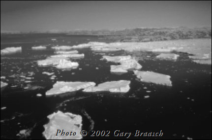
To document changes in Arctic ice, I flew on a NASA laser mapping plane that found that Greenland’s outlet glaciers appear to be moving faster and creating more icebergs in the north Atlantic. I can photograph the melting Arctic ice, but its crucial influences on earth’s weather cycles are subtle—so far. However, a theory that increasing meltwater from the Arctic will eventually disrupt the Gulf Stream might be tested sooner than expected, according to new research by the Woods Hole Oceanographic Institution. This year its research ships found the most Arctic water ever in the Labrador Sea.
A rise in summer temperatures might sound like good news, but its effects are ominous and beginning to show. I’ve witnessed insect attacks that have killed four million acres of white spruce in Kenai, Alaska. Changes correlated with temperature rise threaten all the boreal forests that ring the Arctic and comprise one-third of the world’s forests. At the same time, the boreal forest and its associated shrub population are starting to migrate north, overtaking the native tundra. Geophysicist Tom Osterkamp’s research shows Alaska permafrost temperature has increased up to 1.50 degrees centigrade since 1980. At his temperature site near Denali National Park, Osterkamp can show how far the once-frozen tundra has subsided. The damage from collapsing permafrost extends from the Fairbanks area north to the Arctic Ocean coast.
The native village of Shishmaref on the Bering Sea is losing houses rapidly to permafrost thaw and rising sea level. Such scenes are repeated around the entire Arctic shore. Some native prey animals—walrus, seabirds, caribou—are beginning to be affected. In some areas, polar bears cannot reach their prey due to diminished sea ice. Perhaps most threatening, dying forests, thawing permafrost, and drying tundra are beginning to pump a huge flux of carbon dioxide and methane into the atmosphere in a region that once served only as a carbon absorber. This feedback loop could combine with increased absorption of solar heat by open tundra and ocean to escalate the rate of change.
